Nine Wake Forest areas, from downtown and the historic district to Heritage and Traditions: zoned high school, U.S. 1 exit and August 2026 home value.
Last checked Oct. 12, 2026. Sources: the Town of Wake Forest’s historic districts page, Northeast Community Plan and South Main Street Corridor Study, OpenStreetMap, the Wake County Public School System’s current base attendance areas, the N.C. Department of Public Instruction’s 2025-26 accountability data, the U.S. Census Bureau and Zillow Research.
Wake Forest has about 52,844 residents, according to the Census Bureau’s 2020-2024 American Community Survey on its QuickFacts page. The town grew up around Wake Forest College, which left for Winston-Salem in 1956; Southeastern Baptist Theological Seminary now occupies the old campus (see our history and landmarks guide). This guide splits the town into nine areas that a town plan, a historic district or OpenStreetMap names and maps, and gives each one its schools, home values, parks and commute.
What this means for you
- One ZIP code: all of Wake Forest is in 27587, so ZIP-level home values are the same for every area. Zillow’s index for 27587 was $508,282 in August 2026.
- Schools by address, not by town: check every address in the district’s base school lookup.
- Town limits are patchy: many streets on the edges are outside the town. Check a parcel on Wake County’s iMAPS.
How the town is laid out
- U.S. 1 (Capital Boulevard) runs north and south along the west side of town. The two Wake Forest exits are Exit 124, N.C. 98 (Dr. Calvin Jones Highway), and Exit 125, N.C. 98 Business (Durham Road), in NCDOT’s interchange inventory. Interstate 540 is about 9 to 13 miles south, depending on the area.
- South Main Street (U.S. 1A) links U.S. 1 with downtown, and the CSX S-Line railroad runs through downtown. More in our getting around guide.
- Two counties: most of the town is in Wake County; the northern part is in Franklin County, which bills its own property tax and runs its own schools. See our property tax guide.
- School zones do not follow town limits. Within the Wake County Public School System, the same street can split between two elementary schools, and several of our areas split between Wake Forest High and Heritage High.
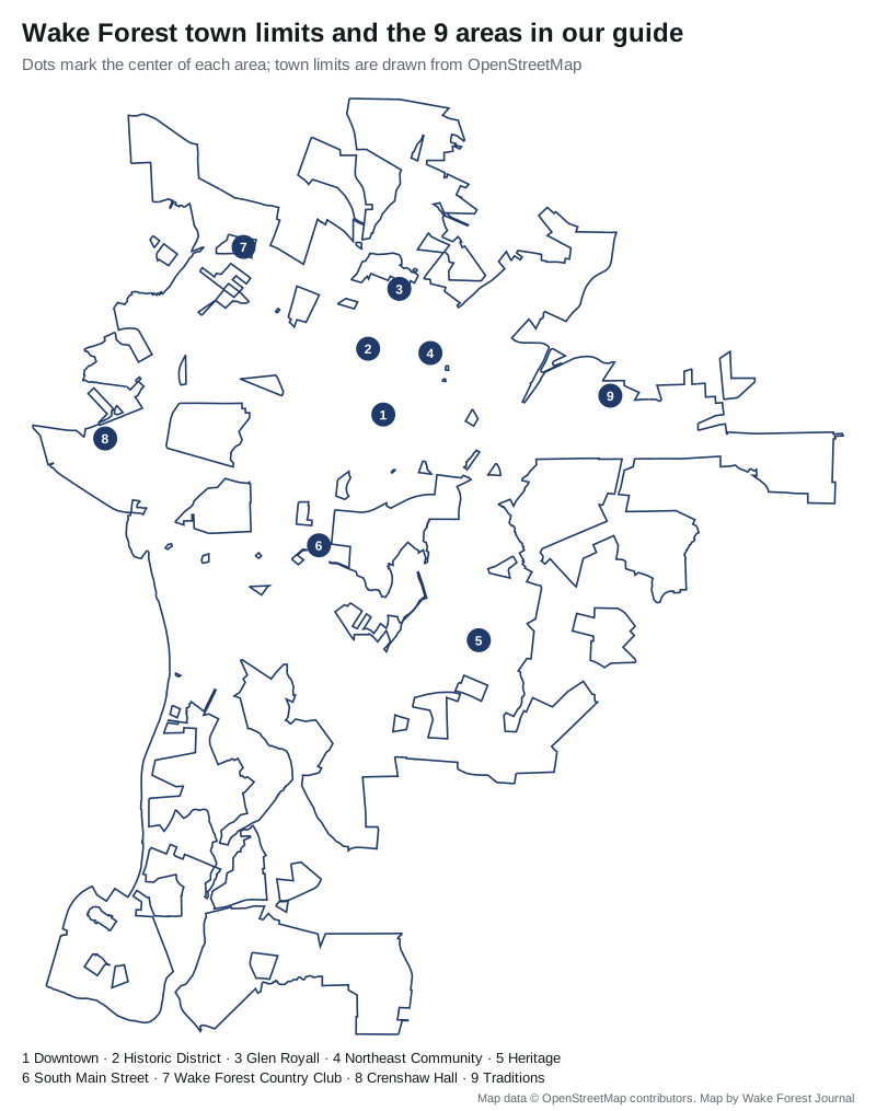
The nine areas at a glance
| Area | ZIP | Zoned high school | Home value, ZIP 27587, Aug. 2026 | Guide |
|---|---|---|---|---|
| Downtown | 27587 | Wake Forest High | $508,282 | Downtown |
| Historic District | 27587 | Wake Forest High | $508,282 | Historic District |
| Glen Royall | 27587 | Wake Forest High | $508,282 | Glen Royall |
| Northeast Community | 27587 | Wake Forest High | $508,282 | Northeast Community |
| Heritage | 27587 | Heritage High | $508,282 | Heritage |
| South Main Street | 27587 | Heritage High or Wake Forest High | $508,282 | South Main Street |
| Wake Forest Country Club | 27587 | Wake Forest High | $508,282 | Wake Forest Country Club |
| Crenshaw Hall | 27587 | Wake Forest High; Wakefield High on some streets | $508,282 | Crenshaw Hall |
| Traditions | 27587 | Wake Forest High | $508,282 | Traditions |
The zoned high school is the one most of the points we checked in each area were assigned to in the district’s current base attendance areas. The home value is the Zillow Home Value Index for ZIP code 27587, a modeled typical value for the middle third of homes, not a sale price; it was down 0.8% from $512,457 in August 2025, and Zillow’s figure for the town as a whole was $507,240. More in our home prices guide and schools guide.
The areas
Downtown. The South White Street commercial blocks around Town Hall, listed in the National Register of Historic Places in 2002. Home of the town’s social district and the start of the WRX express bus to Raleigh.
Historic District. The old Wake Forest College campus and the homes around it, listed in 2003, with the town’s local historic district along North Main Street, where exterior changes need town approval.
Glen Royall. The mill village north of Oak Avenue, begun in 1900 and listed in 1999. The mill closed in April 1976; most of its houses still stand.
Northeast Community. More than 315 acres east of North White Street with its own town plan, Ailey Young Park and the site of the W.E.B. DuBois School. The proposed East End Historic District went on the state’s study list in June 2026.
Heritage. The planned community on the south side, with Heritage Elementary, Middle and High, townhouse and apartment sections, the Smith Creek Soccer Center and two greenways.
South Main Street. The U.S. 1A corridor between downtown and U.S. 1, with old Forestville, Tyler Run Park, the town’s biggest cluster of supermarkets and the WRX bus. High school zones split here.
Wake Forest Country Club. Neighborhoods on the north side between Capital Boulevard and Joyner Park, the town’s largest park, about 1.6 miles from Exit 125.
Crenshaw Hall. Neighborhoods west of U.S. 1 along Durham Road, about 1.2 miles from Exit 125, with Plummer Park and the Crenshaw Corners shops.
Traditions. Neighborhoods on the east side around the Wake Forest Reservoir, all zoned for Richland Creek Elementary, Wake Forest Middle and Wake Forest High.
Areas we left out
- Wakefield, southwest of town, is inside Raleigh’s city limits and in ZIP code 27614, according to the Census Bureau’s geocoder, though the town’s Go Wake Forest service reaches part of it. See our neighbors in your town, county and neighbors.
- Hasentree, west toward Falls Lake, and Heritage East are mapped on OpenStreetMap outside the town limits.
- Olde Mill Stream and other neighborhoods OpenStreetMap names are not covered separately; OpenStreetMap names more than 100 in and around town, most of them single subdivisions.
- The Franklin County part of town, to the north, is served by Franklin County Schools, not the Wake County system; see our schools guide.
How we built this
- Areas: the town’s historic districts page and map (PDF) (Downtown, Historic District, Glen Royall), the Northeast Community Plan, the South Main Street Corridor Study, and neighborhood and place names mapped on OpenStreetMap (Heritage, Forestville, Wake Forest Country Club, Crenshaw Hall, Traditions). The town does not publish a neighborhood or HOA registry that we could find.
- Schools: we tested between 25 and 153 points in each area against the Wake County Public School System’s current base attendance areas, and took scores from the state’s 2025-26 accountability data.
- Town limits: OpenStreetMap’s Wake Forest boundary, checked against the Census Bureau’s geocoder.
- Distances: measured on the OpenStreetMap road network; they are distances, not drive times.
- Home values: the Zillow Home Value Index, August 2026.
Comparing whole towns? See Wake Forest vs Rolesville vs Raleigh vs Knightdale. New in town? Our moving to Wake Forest guide has the checklist.
Frequently asked questions
What are the neighborhoods in Wake Forest, NC?
Our guide covers nine areas: Downtown, the Historic District, Glen Royall, the Northeast Community, Heritage, South Main Street and Forestville, the Wake Forest Country Club area, Crenshaw Hall and Traditions. Each has its own page with schools, home values, parks and commute.
What ZIP code is Wake Forest?
Wake Forest is in ZIP code 27587. The Zillow Home Value Index for 27587 was $508,282 in August 2026, down 0.8% from a year earlier.
Which high schools serve Wake Forest neighborhoods?
Most of the Wake County part of town is zoned for Wake Forest High or Heritage High, and a few edges for Wakefield High. Zones do not follow town limits, so check every address with the district’s base school lookup. The Franklin County part of town is served by Franklin County Schools.
Is Wakefield in Wake Forest?
Most of Wakefield is inside Raleigh’s city limits, in ZIP code 27614, according to the Census Bureau’s geocoder, even though it borders Wake Forest. Check a parcel on Wake County’s iMAPS.
Have your say