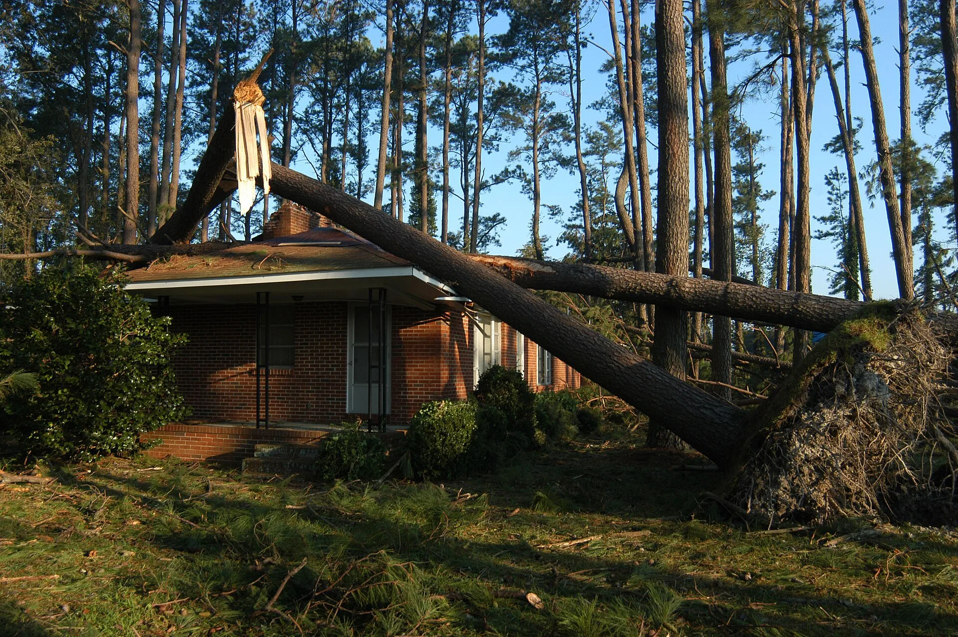
An EF1 tornado with 107 mph winds ran 2.5 miles from Stone Ridge to Neuse Crossing, 6 to 8 miles south of Wake Forest, on Oct. 11. A second EF1 hit near Louisburg.
A tornado warning covered Wake Forest for 51 minutes on Sunday afternoon as a line of severe storms crossed central North Carolina. The National Weather Service said the storm would be near Raleigh and Wake Forest around 1:15 p.m.
Updated Oct. 16: the weather service has confirmed an EF1 tornado in northeast Raleigh, about 6 to 8 miles south of downtown Wake Forest, under this warning. A second EF1 touched down near Louisburg in Franklin County. The survey details are below.
The tornado the survey confirmed
A damage survey by the National Weather Service in Raleigh found that an EF1 tornado touched down at 1:12 p.m. Sunday in the Stone Ridge neighborhood, just south of Interstate 540. It traveled north into the Neuse Crossing neighborhood and lifted near Mitchell Mill Road at 1:17 p.m. The weather service calls it the Perry Creek tornado.
| Survey finding | Perry Creek tornado, Wake County |
|---|---|
| Rating | EF1 |
| Estimated peak wind | 107 mph |
| Path length | 2.51 miles |
| Widest point | 150 yards |
| Time on the ground | 1:12 to 1:17 p.m. |
| Deaths or injuries | None |
The survey describes “a discontinuous path of tree and structural damage.” The path ran from about 8 miles to about 6 miles south of downtown Wake Forest. It matches the 911 reports of trees on houses logged between 1:10 and 1:17 p.m., in the table further down.
A second survey confirmed an EF1 tornado southwest of Louisburg in Franklin County, about 11 miles northeast of Wake Forest. It touched down at 1:42 p.m., reached an estimated 110 mph and crossed N.C. 56 just west of Timberlake Road over 1.93 miles. The survey found mostly tree damage, with some damage to buildings and fences, and no injuries.
The weather service says both ratings are preliminary until it publishes its Storm Data record.
The warning
The National Weather Service in Raleigh issued the warning at 1:09 p.m. It covered northeastern Wake County and southwestern Franklin County until 2 p.m.
The warning said radar showed rotation in a storm near Raleigh, moving northeast at 20 mph. It listed these places in the storm’s path:
- Raleigh and Wake Forest, around 1:15 p.m.
- Rolesville, Youngsville, Falls Lake, Knightdale and Pilot
- Interstate 540 between mile markers 12 and 24
- Interstate 440 between mile markers 6 and 16
The warning text is on the weather service’s list of Raleigh office tornado warnings. It was one of 16 the Raleigh office issued across central North Carolina on Sunday.
What was reported near Wake Forest
The weather service logs storm reports from 911 call centers and the public. None of the reports it logged Sunday was placed in Wake Forest itself. The closest came from northeast Raleigh, Youngsville and eastern Franklin County. They are in the office’s local storm reports.
| Time | Where, as the weather service logged it | What was reported |
|---|---|---|
| 1:10 p.m. | 3 miles NNE of New Hope, Wake County | Tree on a house on Amber Bluffs Crescent, possible tornado damage |
| 1:15 p.m. | 5 miles SE of Falls Lake, Wake County | Tree damage on Speight Circle, possible tornado damage |
| 1:17 p.m. | 5 miles SW of Rolesville, Wake County | Trees down on Tunas Street and Singleleaf Lane, possible tornado damage |
| 1:17 p.m. | Same area, two more 911 calls | A tree on a house in each, possible tornado damage |
| 1:21 p.m. | Youngsville, Franklin County | Power lines down on Hillsboro Street |
| 1:34 p.m. | 1 mile W of Youngsville, Franklin County | 6 to 8 inches of water on a road |
| 1:40 p.m. | 6 miles W of Bunn, Franklin County | Tornado, reported by the public |
The 1:10 to 1:17 p.m. reports sit in northeast Raleigh, about 7 to 9 miles south of downtown Wake Forest. Youngsville is about 5 miles northeast. The Bunn report is about 8 miles east, under a separate warning for a storm that had crossed Zebulon.
A 911 report is what a caller described. “Possible tornado damage” is the caller’s or the dispatcher’s wording, not a finding. Straight-line wind can snap trees too.
How much rain fell
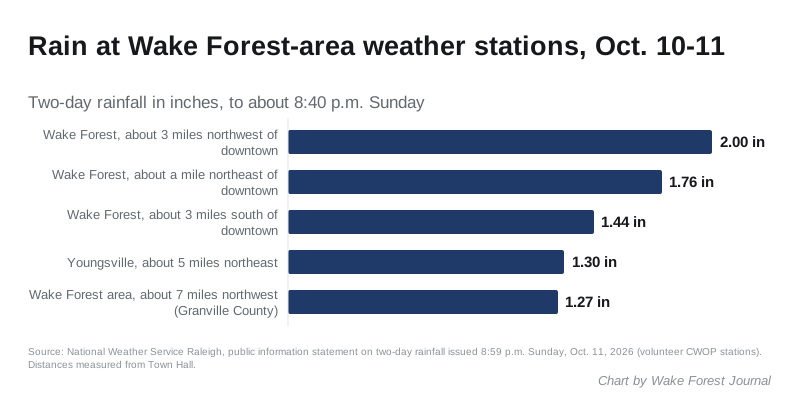
Wake Forest had some of the wettest totals in the region. The weather service’s rainfall summary at 8:59 p.m. Sunday listed two-day totals from volunteer weather stations:
- 2 inches about 3 miles northwest of downtown
- 1.76 inches about a mile northeast of downtown
- 1.44 inches about 3 miles south of downtown
- 1.3 inches in Youngsville
- 1.27 inches at a station logged as Wake Forest, about 7 miles northwest in Granville County
What it means for you
- Downed power lines: stay away and call 911. Wake Forest Power, Duke Energy and Wake Electric each serve parts of the area. Our power outages page has the outage maps and phone numbers for all three.
- The week ahead is warm and dry. The weather service’s forecast discussion early Monday calls for highs in the upper 70s to low 80s Monday and the mid to upper 80s from Wednesday to Friday. A cold front late Friday brings a sharp cooldown, with patchy frost possible over the weekend.
- Branches and limbs: see our trash and recycling guide for how the town collects yard waste.
- Road closures: our road construction and closures page lists current closures in and around Wake Forest.
What happens next
The Enhanced Fujita scale runs from EF0 to EF5. An EF1 means estimated winds of 86 to 110 mph. The Raleigh office surveyed several other Oct. 11 tornadoes across central North Carolina, including an EF1 near the West Regional Library in Cary and an EF0 in Clayton. None besides these two was within 15 miles of Wake Forest.
Have your say